

From Tijuana to La Paz, Our Tips for Driving the Baja Peninsula
If you’ve read our Driving Baja Part 1 and Driving Baja Part 2 posts in this series, you’ve learned how to prepare for the your Baja road trip, and now have some insights on how and where to cross the border. In our third and final post in this series, we give you tips for making the drive from the US/Mexico border to La Paz in Baja California Sur.

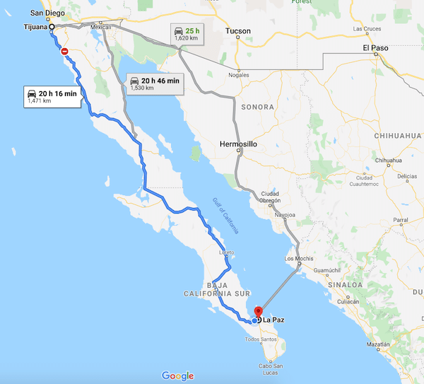
The drive from Tijuana to La Paz typically takes a minimum of two to three days, depending on your plan. The trip measures around 1,470 kilometers, or roughly 900 miles. (It’s another 2 hours from La Paz to Los Cabos at the very end of the peninsula). Below, we discuss the different segments of the journey, along with a few popular stops along the way that we have used.
Of course, you can also use this post as a start to create your own extended tour of Baja. In fact, if you have the time, we recommend it! You’ll be amazed at both the diverse scenery and the friends you will meet along the way.
Which Route Should I Take?
For the purposes of this article, we will assume you are driving Baja for the first time, possibly bringing a carload or towing a trailer full of stuff, and want to complete the trip as soon as possible. The route you take south from the border depends on where you cross, and how much time you want to take to arrive at your destination in La Paz.
If you want to complete the trip as soon as possible, you can get from Tijuana to La Paz in two days. However, be aware that in the winter you will need to get started very early to avoid driving in the dark at the end of the day to reach your destination. This route requires only one overnight stop, but because each day is fairly long, it’s a good idea to have two people who can share the driving.

The three-day option gives you a bit more time to enjoy the drive and take in the Baja scenery. This option also gets you off the road early enough each day to avoid driving in the dark (see our Baja Driving Tips below). It is also a better choice for those who are traveling with pets, and want or need to take more breaks along the way.
Baja Road Trip Options
2-DAY TRIP:
Day 1: Tijuana to Guerrero Negro (10+ hours).
Hotels: Stay at Hotel Terra Sal or Halfway Inn.
Day 2: Guerrero Negro to La Paz (10+ hours)
3-DAY TRIP:
Day 1: Tijuana to El Rosario (5+ hours). Hotels: Stay at Baja Cactus Hotel or Mision Santa Maria.
Day 2: El Rosario to Santa Rosalia (8+ hours) Stay at Hotel El Morro or Hotel Las Casitas.
Day 3: Santa Rosalia to La Paz (7.5 hours)
If you are crossing the border from the San Diego area in California, Transpeninsular Highway 1 (MX-1) is the route you will use to get here. (See our post about which border crossing to take here.) MX-1 is a paved highway that runs the entire length of the Baja peninsula from Tijuana to Los Cabos. The highway is in good shape and relatively easy to drive, with a few caveats (see our Baja Driving Tips below). If you are crossing further east at Mexicali, you can also take Highway 5 south to where it joins MX-1 further down the peninsula. We have not recommended this route in the past because it included a 20-25 mile stretch of very bumpy dirt road under construction. We’ve heard reports that the paving has recently been completed on this stretch, but because we haven’t driven it ourselves, for the purposes of this article we’ll stick to talking about the MX-1 route. Regardless of how long you take to make the drive, we recommend starting your day by crossing the border early in the morning, when traffic south is at its lightest.

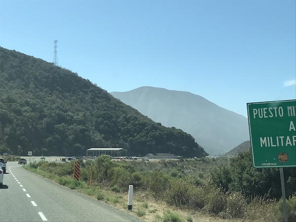
Military Checkpoints
Along the way, you will pass through a number of military checkpoints. The checkpoints are there to make sure nothing illegal is being transported. Don’t be intimidated, the service men and women operating the checkpoints are typically very friendly and polite. They will usually either just wave you through, or ask a couple of questions about where you are coming from and where you are going, and the length of your intended stay in Baja. Most don’t speak English, so it helps to have a few relevant Spanish phrases saved in Google Translate on your phone.
If they do ask to search your vehicle, it’s not a big deal. Step out of your car, bring your wallet or purse with you, and watch while they search to make sure nothing goes missing. It happens sometimes, but not often. Offering up a cold bottle of water or a Coke is considered a friendly gesture as the guards are often standing for hours in the hot sun.
Tijuana to El Rosario
This segment is only 349 kilometers, or about a 5 hour drive, so it’s an early Day One stop. But, because of the spacing of the towns, it is a good stopping point if you are taking the three-day route. Otherwise, you’ll be continuing on to Guerrero Negro, another 5½ hour drive south. As you approach Ensenada, you will be treated to views of the Pacific Ocean. Expect the occasional traffic and construction delays along the way, Ensenada is the largest city in Baja with over a half million residents. If you need coffee, this is the place to stop, as you won’t find another coffee shop along this route for the rest of the day.
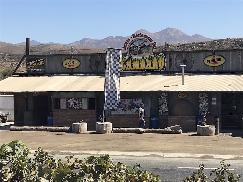
South of Ensenada, we like to stop for lunch at a roadside café named Restaurante Acambaro just north of Santo Tomas. If you’re pulling a trailer or a boat, there is space to pull off on the right side of the highway. The restaurant is across the highway, and there are bathrooms here too if you just need a rest stop. After that, proceed south to San Quintin. From Ensenada to San Quintin can seem like one long stretch of heavy stop and go traffic. Don’t worry, once south of San Quintin you’ll be free of it.

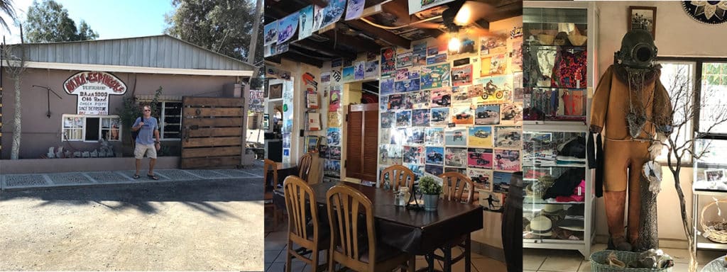
If you’re planning a three-day trip, one option is to stay your first night at the Mision Santa Maria beachfront hotel by Rancho los Pinos (www.misionsantamariahoteles.com), or you can continue for another hour to the Baja Cactus Hotel in El Rosario (http://www.bajacactus.com/). Both offer nice, clean rooms, secure parking, free wifi, and are pet friendly. Mision Santa Maria hotel has an on-site restaurant, and Baja Cactus has a restaurant right next door called Mama Espinosas, a well-known stop on the Baja 1000 tour – its walls are packed with memorabilia. Try the fish tacos or the chile rellenos. Both hotels have a Pemex gas station close by where you can fuel up for the next leg of your journey.

El Rosario to Guerrero Negro
If you’re doing the trip in 2 days, your likely destination the first night is Guerrero Negro, on the Pacific side. It’s another 360 kilometers, or about a 5½ hour drive from El Rosario, so start early if you’re planning to drive from Tijuana to Guerrero Negro all in one day.
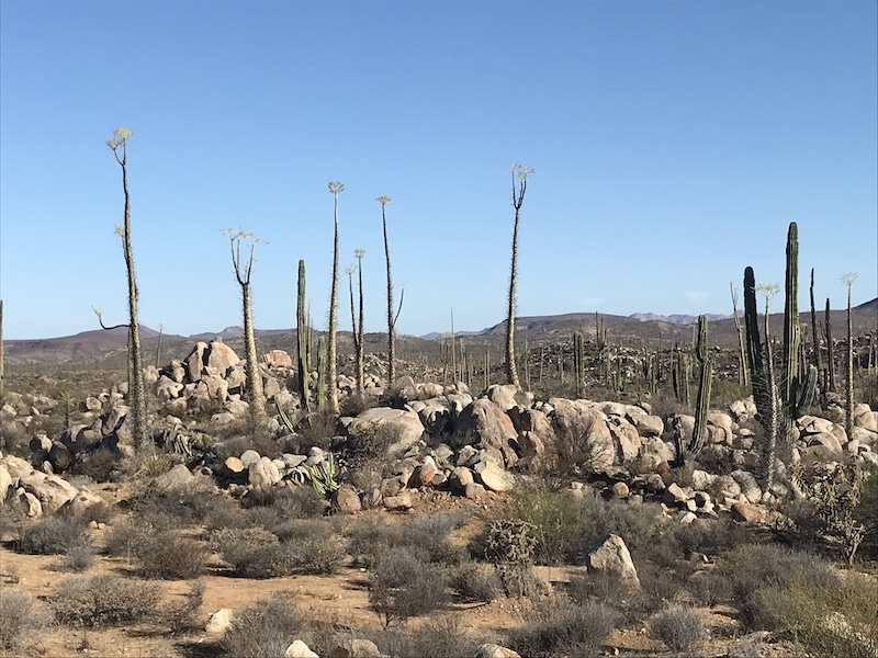
Be sure to fill your gas tank before departing El Rosario, there are no gas stations on the next portion of the drive through the mountains until you approach Guerrero Negro. From El Rosario to Guerrero Negro, the highway winds up through the Sierra de la Giganta mountains until you reach the otherworldly boulder fields of Catavina. The scenery here is dramatic – with giant boulder piles that look like they were created by aliens playing with Tonka trucks. You’ll also see some funny looking cactus called boojum trees you would swear came straight out of a Dr. Seuss book. If you or your furry ones need a rest stop, you can pull off at Hotel Mision Catavina, the only hotel in this area. It has a large parking lot for oversized vehicles, and plenty of room to walk a dog.
You’ll want to drive slowly on this stretch of road, especially going around tight curves in the mountains. You’ll encounter large semis coming from the opposite direction, swinging around curves out into the middle of the highway, and there is often no shoulder and very little space to move over. Slow way down to let them pass.
Another tip: much of the highway is a two-lane road, meaning only a single lane in each direction. When a truck or car in front of you puts on its left turn signal, they are letting you know there is enough room ahead for you to pass safely. Do the same for cars behind you that are traveling faster than you, it’s a courtesy other drivers appreciate.
Just north of Guerrero Negro you’ll finally see a gas station, with a roadside diner next door that serves tasty burritos in the mornings and early afternoon. Once you’ve fueled up, you will continue on towards Guerrero Negro and cross the border from Baja California into the state of Baja California Sur. There is a small agricultural station here where they may stop and ask you if you are carrying any food or plants, and collect an environmental fee.
A popular hotel here with travelers is Terra Sal (http://www.hotelterrasal.com/). It’s just off the highway, has a large, secure parking lot for larger vehicles (including trailers), and an on-site restaurant that is open for dinner and breakfast. The Halfway Inn is another popular choice just north of town and right off the highway. There are also hotels further in the town of Guerrero Negro that are closer to the ocean if you are planning a longer stay here. Guerrero Negro is one of the premier spots for gray whale watching in winter.
Guerrero Negro to Santa Rosalia
If you are taking 3 days to complete the trip, your destination on the second night from El Rosario is likely Santa Rosalia, just 220 kilometers or 3 hours south of Guerrero Negro.
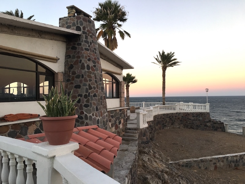
We recommend staying at Hotel El Morro. The hotel has nice, clean rooms, large balconies with stunning views of the Sea of Cortez and is pet friendly (a pet deposit is required). There is also a restaurant on site and secure parking. It’s located right on MX-1, just after you get through town, so you’ll be well positioned to leave early and hit the highway the next morning. Hotel Las Casitas is another similar option on Highway 1 overlooking the ocean.
As you approach Santa Rosalia, you will cross the mountains and drive through the desert until you see the iconic Tres Virgenes, a series of three volcanic mountains rising up out of the desert. From there, you will climb up through another set of mountains and descend back down through switchbacks until you see the Sea of Cortez open up before you. You will be used to this advice by now: drive carefully! The mountain curves are tight and the drop-offs are steep with no guardrails. If you are afraid of heights, it’s a good idea not to look down over the side. Just keep your eyes on the road until you arrive at the bottom in Santa Rosalia. Congratulations, you’ve crossed the entire peninsula and are now ready to make the trek south to La Paz!
Santa Rosalia to Loreto
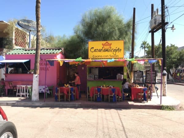
If you are doing the 3-day trip, this day is the best because it is one of the most scenic, and also the shortest day. The first stop south of Santa Rosalia is Mulege, a small town located at the mouth of the Río de Santa Rosalía. Here the elevation drops down and suddenly you’ll find yourself in a tropical oasis surrounded by palm trees. Mulege is a charming town, one of Baja Sur’s pueblo magicos, and worth stopping in for a walk around and an early lunch. We recommend this roadside spot for excellent fish and shrimp tacos, where you can park nearby, eat outside and keep an eye on your car.
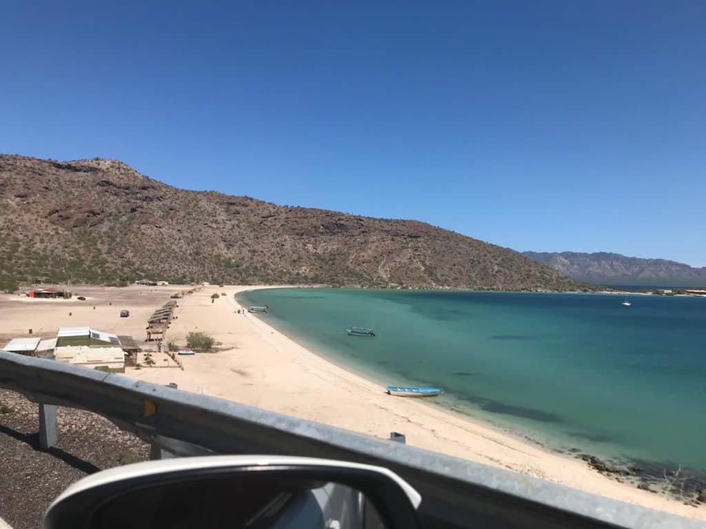
Just south of Mulege is the northern entrance to Bahia Concepcion, a stunning, miles-long bay with some of the most beautiful beaches and scenery in all of Baja. Keep an eye out for the dedicated pull-off vista spots where you can park safely to enjoy the view and take pictures. Further south along the bay, you’ll find Playa Santispac and Playa Requeson, some of the most picturesque of the many beaches along the drive. If you’re traveling in warmer weather, you may well find yourself pulling off at one of these white sand beaches just to jump in the crystal blue water. Trust us, it’s nearly irresistible.
Once you’ve left Bahia Concepcion, you’ll head south to Loreto, another of Baja Sur’s pueblo magicos. A fun fact: Loreto is considered to be the first human settlement in Baja California Sur, and is home to prehistoric cave paintings and petroglyphs dating back thousands of years. Today, the town is home to the golf resort Villa del Palmar.
If you didn’t stop to eat in Mulege, you’ll find plenty of restaurants in town here just off the highway. For an inexpensive stop on the Malecon with great food and a view of the water, try Restaurante Bar Los Mandiles.
As you drive through Loreto, you’ll be surrounded by the Sierra de la Giganta mountain range on one side and gorgeous ocean views on the other. Fun fact: this part of the Sea of Cortez is home to blue whales, the largest mammal on the planet.
Loreto to La Paz
From Loreto, you will head back toward the middle of the peninsula one more time, and south through Insurgentes and Constitución, two towns close to the ports of Adolfo Lopez Mateos and San Carlos on the Pacific side, where you can go gray whale watching in winter. From here, you’ll zig southeast again towards the Sea of Cortez, up across a mesa at the top of another mountain range, and finally down the last hill into La Paz. We’re not going to lie, this part of the drive is probably the least interesting, and by now you’re more than ready to reach your final destination in La Paz! As you approach the city, you will be rewarded with a view of the Bay of La Paz stretching out below. You’ll go through one final agricultural checkpoint, and from there you will arrive in El Centenario, a quiet community about 20 minutes outside of downtown La Paz. Breathe a big sigh of relief, you made it! You are now a Baja road warrior, and will soon be sitting with a margarita and telling tales about your Baja road trip.
Baja Driving Tips
Below are some tips and tricks to help make your Baja road trip as safe and smooth as possible:
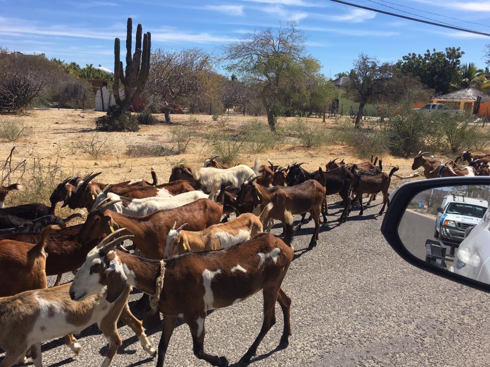
Drive slowly! In Baja, cows, horses, goats and other animals roam freely. It’s not uncommon to come around a curve and see a heard of goats or a cow standing in the middle of the road. Also, MX-1 is the main transportation route from Baja to the US and Canada, so you’ll often encounter large 18-wheel semis and other assorted vehicles driving this route. The road is often a single lane in each direction, with no shoulder, even on the steepest mountain curves. Large trucks can take up much of the road coming around those curves, so take your time, drive slowly and be prepared to stop at any time.
Watch for topes (speed bumps): You’ll encounter topes, or speed bumps, throughout Baja, especially when approaching and leaving most towns. Many are unmarked, so remember to slow down and look out for them as you are entering and leaving even the smallest of villages.
Don’t drive at night. This advice has little to do with crime and more to do with visibility. While drivers in the US and Canada may be used to well-lit highways, exits and directional signs, in Baja there is little or no ambient light after dark. There may be large potholes in the road, and animals are known to lay down on the highway at night to keep warm. If you’re traveling after dark, you won’t see them until it’s too late. Plan your trip well and make sure you can get to your destination at or before sunset.
Keep your gas tank full. There will be long stretches with no gas stations, so plan well and fill up any time you get below a half tank. Don’t rely on maps that indicate gas stations in remote areas, they may be closed or no longer exist. Stop in the towns mentioned here to top off your tank, check that your tires are all ok and any cargo is still firmly attached.
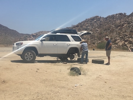
Roadside assistance: If you do break down or get a flat tire, you will soon experience some of that Baja magic you’ll hear people talk about. Even in the most remote locations, a passing motorist or local will often suddenly appear out of nowhere to help you in an emergency. Don’t be suspicious, the locals here are genuinely friendly and eager to help. If it happens, offer a tip, although it will usually be refused. If no help is in sight, and you have cell reception, you can call the Green Angels. Similar to AAA in the US, these are fix-it crews in green and white trucks, paid by the Mexican office of tourism, that patrol the highway and will help you fix or tow your vehicle for free. The 24-hour toll-free number to call for the Green Angels is 01-800-987-8224, or from your cell phone you can just dial 078.
Stop signs. Right of way can be a bit tricky in Baja, since it’s not as clear-cut as it is north of the border. Generally speaking, at a four-way stop, the first person to arrive at the intersection has the right of way (always yield to pedestrians). However, drivers here don’t tend to follow the right side tie-breaker rule, so be careful if you arrive at the same time as another vehicle (and don’t be surprised if they assume the right of way). Regardless of how the locals drive, it’s always a good idea to come to a full stop at stop signs, and cede the right of way if there is any doubt.
Traffic lights. These also work similarly as they do up north, but with a notable exception. Following the green light is a flashing green light, which in Baja is treated the same as a yellow light. The flashing green then turns to yellow and very quickly to red. Green means go, but if you see a flashing green, slow down as you would for a yellow light. If the light turns yellow, don’t run it, definitely prepare to stop.
Watch for left turns. You may occasionally come upon a vehicle driving slowly in the left lane. In most cases, the vehicle needs to turn left soon and is preparing to do so. Turn signals are somewhat optional, so be aware that the vehicle may slow or even stop. Remember, in Baja a vehicle ahead of you with its left turn signal on is likely signaling you that the road ahead is clear and it is safe to pass. The drivers here are mostly friendly that way!